


Writing a brief summary of the history of Solin, formerly the capital of a Roman provinence and describing its improtant monuments, is a task both appealing and hard. It is well known that Salona disappeared at the end of classical epoque, never to be renewed again. In the middle ages, the Salonitan town area, the entire former Salonitan ager, established at the end of Roman republic, was between three important centres that were often in collision: between the towns of Trogir and Split, and the Klis fortress, for a long time in possession of the Croaitan dignitary families and then by Turks. This inevitably determined the destiny of the former town of Salona, the present Solin, and its environments.
The Town’s Name
The present Solin’s name, the urbonim Salona, appears in the Latin language as both the singular Salona and the plural Salone (-ae). The form Salona is similar to several contemporary town, river and mountain names, such as Albona (the present Labin), Flanona (Plomin), Aenona (Nin), Scardona (Skradin), Narona (this name has been preserved in the name of the present Norin river, whereas the very town name has disappeared), Promona (the present Mount Promina). All these names originate from the Illyrian settlement, river or mountain names. It is hard to explain as to why Solin’s ancient name appears in two forms: singular Salona and plural Salonae. A solution has been offered by the archaeologist Duje Rendić Miočević, where the plural form was to denote the “region of Salona”, that is, a wider area where the future town of Salona was to be created. There is a later explanation, set by the archaeologist, Nenad Cambi. But here is a brief digression before that!
There have been attempts to establish the location of the first prehistoric and early-historic Illyrian settlement for a long time. It is known, however, that in the first half of the 1st millennium B. C., perhaps even before that, the Illyrian tribe of the Delmats founded many settlements on smaller hills along the seacoast and by the Salon river. By analogies established by comparing similar living and land examples, such a settlement should be imagined elevated on a hill, the exact location of the settlement being quite hard to determine due to the changed relief of the entire Salona area. Ivan Marović, a fine connoisseur of this prehistoric époque, proposes that the then “Salona” could have been located on an elevation along the lower slopes of Kozjak or Mosor mountains. Similar settlements, especially of the hill-fort type, certainly existed elsewhere too, eastward, below the Klis pass, and westward, in the Kaštela Field.
According to the archaeological finds presently known, there were hill-forts (oppidum) below Klis, near the Jadro spring and on the nearby mountains slopes. It is certain that a hill-forth existed below the present Fort Klis, two on the Markezina Greda ridge, and one each on Klis Kosa, Ozrina, Zagradina, Sv. Jure above the Jadro spring, etc. In the village of Uvodići, southeast of Klis, at the locality known as Gradina (Croatian for hill-fort), there are Roman époque remains: walls, a cistern, an inscription celebrating Jupiter cut into the rock, horse-pulled wagon tracks cut in the rock (spurillae). Above Rupotine village there is Žižina Glavica hill, and an early and very important settlement structure was established recently in the area of Donje Rupotine, on the eastern slopes of Mount Kozjak. There, on the slope cut by the ancient Solin-Klis road, there are, among others, structures of a large fortified complex.
Interpreting these remains, running west - east, about one kilometre long and over one hundred meters wide, situated along the slopes on both the left and the right side of the road, Nenad Cambi has offered an interesting solution to the problem of the town-name plural form – Salonae. Taking into consideration some earlier opinions and assumptions, he considers that it was a 3rd-2nd century B.C. Illyrian oppidum (a fortified settlement or town) that lasted till much after that time. This assumption is supported by remains of a quadratic building, probably a temple, of the late republic or early imperial époque. The said oppidum *was surrounded by the so-called megalithic walls, WHICH WERE built in large stone blocks. Cambi considers that all those small and separate prehistoric settlements, including the Rupotine oppidum, were named at the same name, this being a reason for the town sometimes being named in the plural Salonae sometimes. The settlement in Rupotine would *be one of the settlements founded in the vicinity of the Salon river and on THE slopes of the surrounding hills. However, it was another settlement, closer to the sea, that gained the role of the regional capital in the course of time. Thus, there were several Salonas, settlements situated close to each other, around the river spring below Klis and both eastward and westward from the river, united under the same basic name. We should add: the name was taken from the river that ran in the vicinity. Thus, the plural form would be older than the singular.
However, it should be pointed out here that the plural name survived a long time, being mentioned in documents such as those by St. Jerome (4th-5th century), Eutropius (second half of the 4th century), Prosperus Tyro Aquitanus (about 390 – about 426/8), Marcellinus comes (5th century), etc. The final definitive reason seems, however, not to have been found. If accepting the Cambi’s idea, there remains a need to explain the later plural forms of the name and reasons of their use in reliable sources, texts written by the above mentioned late-Roman writers.
Proto-historic Epoch
The above mentioned geographic attributes of the area attracted people to settle here, to exchange their goods and products, but also ideas – the culture. It is very likely that the same reasons brought to this attractive land the Greeks and the Delmats – the Illyrians, later also the Italics.
This thesis on an earlier settlement is based on, as a matter of fact, rare artefacts testifying man’s presence, probably as early as in the Neolithic (the later stone age) and on, uninterruptedly in early historic times, when the town started developing. There are no archaeological finds concentrated at one place that would testify to a settlement of that time. However, in its wider surroundings, and in the area of the neighbouring Split convincing evidence of life in the first phase of human history have been found. People also lived in caves in the nearby Kozjak and Mosor mountains, beside mountain passes, along the ancient roads (Klis), on islands (Brač and Hvar), etc. The present Solin, thus, just like many other Adriatic towns, was founded in some ancient past.
Some bronze-age and iron-age artefacts (jewellery and arms), found in the wider area of Salona, are of Illyrian origin, others are of Greek origin. These artefacts provide strong evidence of trading contacts between the Illyrian natives and the Hellenic world, established just in the Salona area. For example, the small ceramic vessel (pixida) of Greek - Corinthian origin (6th century B.C.), decorated with animal and plant motives; an Erot-shaped earring also of Greek origin, found in the locality of Majdan, below Mount Mosor (4th/2nd century B.C.). Greek products penetrated deep into the hinterland by various means including along the Naron river (the present Neretva river). Thus, at the archaeological site of Glasinac, near Sarajevo, there are both pieces of warriors’ equipment and jewellery of Greek origin, and in the region of Lika there are amber artefacts.
Besides these scarce archaeological finds, the few historic sources testify about the contacts between the local population and the Greek colonists too, the entire body of data providing hints about the early history of Solin.
A somewhat later époque is evident from the so-called megalithic walls, which were built in large stone blocks, at the eastern side of the first town, next to the town gates and from a large capital with bull heads (its importance for dating the beginnings of the town has been reiterated by Nenad Cambi recently). The capital could only have been part of a very monumental building built in the first half of the 1st century B.C. It could only have been created in an existing town!
When did Salona start its urban rise, when it reached the status of the province capital? There is a quite reliable answer to this question: about the late Hellenistic époque, at the time of Greek colonisation of both Adriatic shores, the Croatian and the Italian.
The oldest written evidence about the Adriatic can be read in Greek writers’ texts, reaching back into the Classic époque. It was mentioned at the time of the founding of the Greek settlements in the Mediterranean in the then myths, also by poets and other writers, by geographers and travel writers. There is further evidence from the middle of the 1st millennium B.C., with the increased contacts between inhabitants of the eastern Adriatic coast and the Greek merchants and seafarers who sailed to the mouth of the Po, on the Italian coast. The island of Vis, situated in about the middle of the coast and relatively the closest *to the Italian shore, made a perfect port of call for this long voyage.
In the beginning of the 4th century, events took place that greatly influenced the overall events in the Adriatic: The Greeks of Syracuse, urged by their ruler Dionysius’ policies, firstly founded the colony Issa, at the location of the present town of Vis, Vis island, in a sheltered bay, on sunny slopes of a small hill, then Pharos, in the present Stari Grad Bay, Hvar island. This is the time when Ancona and Numana where founded on the western, Italian, coast of the Adriatic. Issa became a rich Greek town, the promoter of the Greek interests at the eastern Adriatic coast, that, probably in the 3rd century, founded its outstation-towns on the mainland: Tragurion, the present Trogir, and Epetion, the present Stobreč. There is substantial evidence of the many Greek contacts with the eastern Adriatic lands, that is, the Illyrian population along the coast and in the Dalmatian hinterland. Trading was quite advanced. In the centre of all that area there was the Illyrian, that is, the Delmat, Salona or Salonae. It was not a Greek town, in spite of the Greek presence in it!
Salonae or longae Salonae, as the town is named by the Roman poet Marcus Anneus Lucanus (39-65) in his poem Pharsalia, gradually concentrated to one spot in the early Roman, i.e. the Republic, époque. That is the settlement nearest to the sea, given the role of important port of the Delmats, i.e. their exit to the sea, by the Greek writer Strabo (about 64 B.C. – about 19 A.D.) in his Geographica.
The Roman Epoch
In the last centuries of the Old Ages, the Salona area became very much of interest to Roman (Italic) merchants, and therefore to the state politics of Rome. For a long time, Rome had tried spreading its economic interests to the Balkans and the deep and rich Illyrian lands. Following the fall of sea forces of the Illyrian Queen Teuta and her husband Agron (3rd century B.C.) in the south Adriatic that, like the pirates of the Neretva and of Omiš in the centuries to come, disrupted traffic between Italy and Greece. The Roman penetration started for Macedinia in the south and to Veneto in the north. The colony of Aquileia was founded, Istria was conquered, and the armies reached as far as Sisak (then Segestica, Siscia). In the mid 2nd century B.C., occasional conflicts with the Delmats started, they were to last over one hundred years. It was thus only in the year 27 B.C. that Octavian defeated the Japods, the Delmats and the Pannonians, to annex Illyricum to the Empire. The large Illyrian province was split into two: Pannonia and Dalmatia, gaining Salona further importance of being a large town in Dalmatia.
During these centuries, the Italics started arriving in this area to these lands, probably many of them to Salona (probably mostly merchants, seafarers and some craftsmen) when, in 119 B.C., the Roman army-commander, consul Quintus Caecilius Metellus, decided to winter with his army here. Namely, he required a safe place to stay and friendly inhabitants in order to have the army rested before the spring campaign against the Illyrians. This is the year of the first mention of Salona in a written historic document.
However, it should be assumed that Roman influence in Salona grew following their victories against the Illyrian Delmats, and especially after the war between Gaius Julius Caesar and Gnaeus Pompey… Some crucial battles took place on the eastern Adriatic shores as well. Salona took the side of the winning Caesar. In his famous De bello civili (Lib. III), Caesar mentioned, among others, the frequent warfare in the areas of Salona. For its faithfulness in the war, probably about 48/47 B.C., Caesar advanced Salona to the rank of a Roman colony, naming it Martia Iulia Salona. This started the decline of influence of the Issean Greeks in the town, and Salona grew into a true Roman town in formal and urban senses as well as cultural. In the town strucures were built corresponding to Roman living standards such as forum, basilicas (curie), temples, thermae, theatre, amphitheatre, etc. On the other hand, the local life got impermeated by Roman institutions, administration, legal norms, religion and its cults that mixed with the old, local ones.
At that time, a large division of the Split-Solin-Kaštela Field was made into the colonial ager, and the new population was colonised throughout the area, on plots of land known as centuriae. Such plots of land, equal in size, were in areas recently conquered and annexed to the empire. The Roman state gave them to either veteran soldiers or farmers, thus creating large veteran or agrarian colonies. This area was also inhabited by many new colonists. It is quite certain that the peninsula of Split and the vicinities of Salona were inhabited as well: the areas to the west and the east. That was the ager-territory of the colony of Salona (Colonia Martia Iulia Salona).
At the time of the first emperors, August (27 B.C. – 14 A.D.) and especially Tiberius (14-37) and his prefect for Illyricum, Publius Cornelius Dolabella (14-20), several important roads were built throughout this pacified and subdued region. Some of them started from Salona, via Klis, into the continent: one to Anderium (now Muć), and further westward. Another road went via Tilurium (Trilj), across the Cetina and further eastward to Narona (now the village of Vid near Metković) and the central Bosnia. Yet another road went via Sinj to the colony of Aequum (Čitluk) and further on to Pannonia. Two roads ran along the coast: one to Trogir, and another to Stobreč, the areas below Mount Mosor and further on eastward. Besides these, several local roads were built that connected settlements situated in the closer and farther hinterland. This, too, caused Salona to develop in the centuries of peace that followed, and it grew into a large and important town. An undoubted role in the town’s development was its harbour, visited by mariners travelling along the Adriatic, arriving from both the western and the eastern Mediterranean.
The First Town
This first town, or more precisely, the core of the future Salona, was on the coast. There, by the sea, initially just in the harbour, the first trading and other contacts took place between the Greeks (those of Issa – Vis) and the local Delmats. Salona became the place where the Mediterranean merchants and seafarers met the local population, trading in arms, jewellery, ceramic vessels, etc. They exchanged these goods for leather, cattle, food and, probably, sheep and goat cheese known as caesus delmaticus. The first contacts and trading connections are evidenced by, for instance, the few remains of Hellenic ceramics (3rd-2nd centuries), found at the site of the town forum and the locality known as Manastirine.
There has been much scientific discussion on this first town, its core and its shape. The Danish archaeologist E. Dyggve named it picturesquely urbs vetus, also urbs antiqua and urbs graeca. Duje Rendić Miočević called it urbs quadrata, after the Romulus’ Rome. Dyggve called its western additions urbs occidentalis, and the eastern ones urbs orientalis. All these names are, however, of symbolic and questionable historic significance, given mostly for practical reasons of presenting as clearly as possible its descriptions, some of these lacked historiographic, archaeological or any other argumentation. Therefore, no particular attention should be paid to them in any systematic (scientific) interpretation of archaeological facts. Much more important, but also much harder, is explaining the relationship between the Illyrian, the Greek and the Italic populations, this triple coexistence, a coexistence of three peoples integrated by a town. A town that, by its names (Salona and Salonae, Solin and Solins) and its urban status (oppidum civium Romanorum, also conventus Salonarum, thus with its plural name), still provides scientists with lots of riddles.
Namely, every interpretation of ancient events leaves something open and unsolvable by present knowledge. This, however, does not mean that solutions that approach the ultimate one are not welcome. Still, the Roman imperial époque that followed the establishing of this town, founded in the last century of the old époque, opens fewer doubts. The historic monuments of this époque provide better insight into events embedded in the obscure, proto-historic frame. Such a monument, for instance, is the very badly damaged, yet important inscription found in Salona, the so-called prescript of Salona, where Gaius Julius Caesar, in the year 56 B.C., while a prefect for Galia and Illyricum, took under his protection the Greeks of Salona, endangered by the Italic population that was gaining in power and numbers in the town.
Forma urbis
The oldest part of the town, named picturesquely – as already mentioned above - urbs vetus or quadrata or antiqua or graeca, i.e. the part of the town next to its harbour, gained in importance over the time, becoming the town’s real centre. The town becomes fortified; in the early imperial époque and a bit later (the former half of the 1st century A.D.) the town’s central square was formed, to become the forum soon after. The forum’s structures (capitolium with temples, the curia), somewhat to the south of the theatre and, not far to the west, the amphitheatre. By now, Salona was in the best position to become the administrative centre of the Illyrian province. This first town, the centre of the large Salona in the centuries to come, was trapezoidal in shape and encompassed by walls. These walls are still visible in several places. A part of their remains are the finds next to the town’s monumental gates, the so-called Porta Caesarea (>): a square tower and walls next to it. These walls most probably ran southward as far as to the sea, protecting also the harbour. Namely, the harbour was quite probably protected by walls from both the land side: the eastern and the western. Of the western walls, however, no trace has been found so far.
In this, first, town, there were two main streets, their positions being identified with much certainty: one ran east - west (decumanus), the other north - south (cardo). They are probably of prehistoric origin, influencing the form of the settlement into its street plan. Salona, namely, is not a designed town; it is a town that developed from the inherited situation. Therefore, every expansion of it, especially the one that took place at the end of the 1st and during the 2nd century, happened in the usual manner by using the adjacent spaces: firstly along the road that led from the town westward and eastward. This is why the town destroyed the existing settlements’ cemeteries (>) along these roads and, thus, got its irregular form (>). Over the town annexes, when these were surrounded with walls (>) too, several smaller, secondary gates were built, in the north, northeast and west parts. Some of them have been named by archaeologists: Porta suburbia (the suburban, secondary ones), Porta Andetria (leading toward Muć, then Andetrium) and Porta capraria (Goat Gates, leading toward the fields)… these names being chosen in accordance with the main gates’ names: Porta Caesarea and Porta graeca.
As in the early imperial époque there was no need for fortifying the town, since it was the time of the so-called pax romana (peace throughout the empire), this happened only in the second half of the 2nd century, at the time of Marcus Aurelius (121-180). Then, during the Marcomannic War (166-180), there was a threat of penetration by the Germanic Quadi and Marcomann tribes deeper into the empire in about the year 170. The danger was felt here as well and the town was refortified. A brilliant testimony of this work are inscriptions in stone slabs, built into the outer, northern, wall near the so-called Porta Andetria. The town walls were added, reconstructed and reinforced again during the 5th century, when Salona was endangered by the Huns and the Goths, and yet once again at the time of the Iustinian’s conquering of Dalmatia in the 6th century (>).
A particularly successful period of Salona’s history was the second half of the third century, up to about the time of the emperor Diocletian (284-305). He is believed to have been born in these parts and to have had his famous palace built in the vicinity of Salona for this reason. There is no doubt that Salona, too, profited from such a large building undertaking. Diocletian is a unique reformist of state administration in the Empire. He introduced the so-called tetrarchy, i.e. ruling of four: two Augusts and two Caesars, the latter to succeed to the former. By such decentralisation measures, he gave power to some regions, and by building the palace near Salona he probably, indirectly at least, helped the town to become the focal point of a large area. At that time, Salona was given the honorific title Valeria, which is the emperor’s gentile, family, name. His presence in the palace, where he spent an entire decade, certainly influenced the town’s life.
It is believed that after Diocletian, in Salona as well as in the palace, which was made into a state property. From time to time, emperors and members of their families: Galla Placidia, her son emperor Valentinian III, also Glicerius resided there. The patrician of Salona, Marcellinus, proclaimed himself the king of Dalmatia in 461, his son (nephew) Julius Nepos kept the imperial authority until 480, when he was murdered “in his summer residence” near Salona (the chronicler wrote: villa, which is most probably the Diocletian palace, often named that way). So, formally, he outlived the Western Roman Empire which ended with the Gothic king Odoacar in 476. In this manner, Salona took part in an important change of world history. At that time, the town, of course, had the town-planning references and standards requested by the state and ecclesiastical elite.
What was the population of Salona at its peak?
This can be answered only approximately, just to satisfy the curiosity evident from the frequency of this question being asked. It is full of local nostalgia as people desired to portray the town as large and as powerful as possible. All the criteria that can be used in determining this fact are still without any firm basis. Numbers such as 40,000, even up to 60,000 inhabitants have been mentioned, being calculated after the assumed number of seats in the Salona’s amphitheatre, water supply capacities, size of the area surrounded by walls (about 500 hectares), etc. It is considered that these figures are very much exaggerated. The number of seats in the amphitheatre, for instance, does not mean that the spectacles were watched by inhabitants of Salona only! They were attended, much like the present sports events, by inhabitants of the surrounding settlements and areas. It is considered that the very town could have been inhabited by fifteen to twenty thousand inhabitants at most, the surrounding areas including the entire ager of Salona, i.e. from the present Podstrana in the east to Trogir, including the peninsula of Split, perhaps even a bit less than that.
Salona - Spalatum
About five kilometres south of the first, Italic-Greek Salona, and the Illyrian Salonae (<), in a sheltered bay, there was the settlement of Spalatum. It was marked in the ancient geographic map known as Tabula Peutingeriana (>). The tabula was most probably made in the 4th or the 5th century A.D. In the map, which is in fact a road map of the Roman Empire, in the wider area of the present city of Split, there are marked and named Tragurium (Trogir), settlement Siclis – Siculi (the already mentioned locality of Bijaći, at the border line of Trogir and Kaštela fields), colony Salona and Epetion (the present Stobreč). The emperor’s palace is not marked, which speaks for the age of the original after which the Peutingeriana has been made.
Even before the final Roman subduing of the Illyricum and the people living there, at the time of Gaius Julius Caesar (about 101 – 44 B.C.). As already mentioned here, the present Split, Solin and Kaštela fields were divided into so-called centuriae. The division is still evident in many places in Kaštela Field, the positioning of some of Split’s streets, such as Zrinjsko-frankopanska, Vukovarska, Zvonimirova, Poljička, Matije Gupca, etc. In addition, there are many smaller and shorter lines recognisable in the local grid as the old Roman land division. Until World War Two, remnants of the old Roman division were even more evident in the countryside with many archaeological finds of all sorts in this area, from buildings to cemeteries, confirms the dense population of the area (>).
The Salona Harbour
The orientation of Salona to the sea and trading with the hinterlands is no exception among all the coastal towns. Similar situations featured elsewhere along the eastern Adriatic coast as well, in Narona, for example. In this, nautical sense, due to some historic circumstances, Salona inherited Issa that was destined for this role by its position in the Mid-Adriatic archipelago in the Greek times. However, being situated on an island, it lacked road connections with the immediate hinterland and the more distant Balkan lands… This was very important for the economy and political aims of Rome. Namely, the Greek dealings with the nearby mainland where there were two trading centres, the Issaic settlements in Tragution and Epetion, and, of course, the harbour of Salona.
It is this very harbour, situated in the eastern part of a sheltered bay, that was a strong influence on the town’s development. Firstly for trade, and, especially in the centuries to come, for the exchange or meeting of people and views of life and religion. Traces of this way of life are quite abundant, evident from archaeological finds, mostly of everyday activities, religious culture, inscriptions, names of persons and places of their origin which can be found on their tombstones. The large number of finds brings light also to the spiritual life of the Salonitans, especially about the sepulchral poetry, including that of the Christian spirit as well.
It is still hard to determine where in Salona the main harbour installations, piers, arsenals, warehouses were situated. Some of them were, for instance, at the side of Vranjic, where there are large oil tanks now! On the northern side, the side of Salona, there were warehouses, excavated in 1986-88. However, we may consider with significant certainty that they existed elsewhere, too: at the eastern end, by the mouth of the river, a delta much different to the present one. The Salon entered the sea in a different way than today, and it also flowed, this should not be forgotten, through a part of the town.
The harbour of Solin, we shall call it by the town’s Slavic name when related to later époques, was economically important in the Middle Ages too. It is very probable that it was used by the masters of Klis for reaching the sea. This is witnessed by an 1171 document that, among other nobility, mentions Vilcodrug nauclueus Clissae – Vukodrag – master of a ship of Klis! Later on, especially at the time of the captain and prince of Klis, Petar Kružić, and his warfare with the Turks, the harbour had an important role in supplying the troops in the Solin fortress (Gradina, >) and in Klis. Kružić himself was killed in battle in Solin’s harbour, when his ship, overloaded with escaping troops was stranded having failed to sail out and escape the Turks.
Frane Božičević Natalis (1469-1542), a contemporary of Petar Kružić and a friend of the Croatian poet Marko Marulić, described the Solin harbour: “Under the town of Klis there is a harbour that can take all the navies of the world. There are ships in it, islands closing and calming the threatening sea. No rolled ropes and no bent-arm anchors are required here to moor the weary ships. By the harbour there is a river mouth where the Jader quietly enters the sea. If this land is conquered by the Turks, you will have barbarians amidst Lazio (Rome).” There were no replies to this and like cries sent to the contemporaries in Europe and the Pope in Rome, the indifference of the Renaissance mind remained cold to the begging of those in jeopardy. No heart heard the fate of this land and its defender, captain Petar Kružić.
Christianity in Salona
No archaeological artefacts of the Christian spirit can be found in Salona or in other Mediterranean towns before the end of the 3rd century. Therefore the question: when did the new religion, calling for salvation, first appear in this town and in Dalmatia? Many scientists have offered their answers, from Frane Bulić over a century ago, to B. Gabričević and N. Cambi and, to the esteemed foreigners J. Zeiller or H. Delehaye, to E. Dyggve, among others. Opinions made by the older ones can be completed, mostly due to different knowledge resulting from new finds obtained in the course of a long period of time, however, no significant change can be made about them.
With some personal additions, the course could be explained as follows.
There is no doubt about the activities of various religious and eastern cult interpreters in the second half of the 3rd century in Salona, much like in other large towns all over the Mediterranean. This includes preachers of the Christian faith among others. Since the 3rd century, this religious following gradually gained more and more believers. The newcomers, coming from the Mediterranean basin; from the eastern coast of the present Turkey, to Jordan, Israel, Egypt, northern Africa and Spain, were of various professions and lifestyles. They were merchants, travellers, craftsmen, slaves, soldiers and teachers. Among them there were many interpreters of oriental cults such as those of Mithras, Isida, Atis, Kibela, etc. The presence of Christian preachers among this colourful folks is clear.
However, what do the historic sources say?
In his epistle to the Romans, St. Paul wrote: “So from Jerusalem all the way around to Illyricum, I have fully proclaimed the gospel of Christ. It has always been my ambition to preach the gospel where Christ was not known, so that I would not be building on someone else’s foundation.” (Romans 15:19) We understand from other Paul’s texts that he touched the borders of Illyricum (the western part of the Balkans) on his third voyage through the eastern Mediterranean. Indirectly, it can be concluded that some of the Paul’s followers visited (preached in?) Dalmatia. Namely, in his epistle to Timothy, written in Rome in the year 67, Paul invited Timothy to join him in that city since his other disciples had gone to various places, “and Titus to Dalmatia” (2 Timothy 4:10).
>From these scarce data, the only ones we have, we may conclude that the first Christian missions did touch Illyricum, but nothing more can be said about them. In those early times, in the first and the second centuries A.D., neither the eastern Adriatic nor the continent had any important trading centres. Neither were there any road hubs of cosmopolitan characteristics where people and ideas would have gathered and where new thoughts and teachings could have appeared and become recognised. Almost none of Illyricum, including Dalmatia, was of any particular interest to the Christian preachers.
The first certain information on Christian faith in these lands comes from the second half of the third century, becoming more evident at the end of that century and the beginning of the fourth century; the time of the persecutions ordered by Diocletian. Of course, it is not impossible that there were Christians in Salona even before the mid third century, they would have been mixed with pagans in a long established tolerant world, perhaps even believers gathered in local Christian communities. This, however, lacks evidence, either in Salona or in other Mediterranean lands. A few Christian symbols and signs do not prove a formed and organised community as those usually founded by the Christ’s followers in towns. Such communities were headed by episcopes (heads, supervisors), assisted by presbyters (seniors) and deacons (servants). The structure was very evident at the time when the persecutions started, preaching the Christ’s teaching having become an expression of resistance and spite, and personal sacrifice an expression of loyalty and belief. Of particular importance were assisting the neighbours, love and understanding, joining in suffering and benefaction. These basic principles were of great importance in the life of the municipality. Later on, particular esteem in Christian communities was enjoyed by the province-capital’s bishop - the metropolitan, the metropolitan of Dalmatia in Salona, for example. These and other ecclesiastical dignitaries, appeared to operate a strong and rich ecclesiastical hierarchy, a great moral and material force on which were laid and structured many medieval centuries.
The last wave of prosecutions affected communities in Dalmatia and other parts of Illyricum, as well. Salona, as the province capital, was the most appealing town for preachers which resulted in the persecutions being particularly numerous here and recorded in both historic literature and local tradition. Thus, amongst the first strugglers for the Christ’s teachings that we have learned of is Venantius, who seems to have been sent from Rome to preach in Dalmatia and Pannonia. Scientific research deems him to have been the first bishop in Salona, at the time of the emperor Valerian (253-260). It is possible that he also preached in Narona, another important emporium on the eastern Adriatic shore, well connected with the continent. It is possible that he also preached in Narona, another important emporium on the eastern Adriatic shore, well connected with the continent. Although we know little about Venantius, perhaps because he has been neglected in the ecclesiastical historiography that wanted to prove apostolic status of the Church of Split and to place it above all others, especially that of Zadar, he was among the most important carriers of Christian belief here. At the time of Valerianus the new religion was freely practised, it was only at the end of his reign when the persecutions started. Probably that is when Venantius was murdered, too, (about 257-260) in one of the first persecutions of Dalmatian Christians.
The most infamous persecutions, when most of the preachers got killed here, were those ordered by Diocletian. Among his victims are Domnio, Anastasius, the priest Asterius, the deacon Septimius and four of the Diocletian’s bodyguards, Antiohie, Gaian, Paulinian and Telie. Domnio – now known as St. Dujam, the patron saint of Split, was the leader of these martyrs, and obviously of the Salonitan Christian community as well, was, according to the legend, of Antiohia in Syria.
Throughout the Roman Empire, the Christian religion achieved its affirmation after its recognition and granting of the right to preach by the emperor Galerie’s Edict of Religious Toleration of 311. Even more so after its prescript by the emperors Constantine and Licinius of 313 known as the Edict of Milan Toleration: the emperors’ written interpretation of questions on the status of the Christians in the empire. The edict granted Christianity full equality with other religions.
Adoration of martyrs was widely practised at that time, as evident from numerous memorials erected above their tombs – from chapels to cathedrals. There are very fine examples of this in Salona.
Turning Christianity into the official state religion did not fully erase the old pagan spiritual world for a long time to come; it remained in the memory and conscience of the people, now Christians. A fine example of such coexistence of ideas and beliefs is the keystone of the Salona’s gate, the so-called Porta Caesarea, Made at the time when Christianity was already well established in the town, the relief shows the pagan goddess Tycha, who, holding a flag and symbols of prosperity in her hands, shows the happy and rich town of Salona. Similar coexistence of paganism and Christianity is evident in cemeteries as well, where tombs were often mixed, Christian tombs being even laid above layers of older pagan graves (in the western necropolis, known as Hortus Metrodori (>), for instance).
Christian towns formed mostly around bishops’ seats, and in Salona also near the first oratorium, which was created, as believed, secretly in a private home . A church was built in the mid fourth century that, over the decades and centuries to come, grew into a large cathedral complex with two basilicas, a baptistery and a bishop’s palace.
Gothic Rule and Justinian’s Reconstruction
At the end of the Old Ages, Roman armies fought at the Empire’s western borders, conquering lands inhabited by the Gauls (now France), Germans (now Germany) and the Illyrians (the western Balkans). A few centuries later, the opposite happened: the Germanic peoples, including the Ostrogoths, attacked the weakened empire and penetrated its territory. The emperor’s commanders waged many wars against them, one of them being known as the Gothic War.
At that time, in the first half of the sixth century, the time of the emperor Justinian (527-565), Salona was in the centre of events as an important stronghold to both the Gothic and the emperor’s armies. While driving the Goths out of this area, the area of Salona, the Roman army firstly seized the fortress (castrum) Klis, as this is described by the historian and chronicler Procopius of Caesarea (first half of the sixth century) in his work The Gothic War. Having entered the town, the Byzantine general Constantian reconstructed the town walls and added triangular annexes to the existing square towers. These were required for the then defence tactics and are still preserved and visible at the northern side of the Manastirine Cemetery. The famous Justinian’s commander Belisarius and his army wintered in Salona in 545, while at war against the Ostrogoths. After that, Dalmatia was ruled by the emperor’s proconsul or prefect, his seat having been most probably in Salona.
The end of the sixth century brought new dangers, but also a decreased interest by the empire for these lands. The priority was, namely, defending Constantinople. Yet, when in 582 the Avars conquered the extremely important town and crossroads of Sirmium, gradual colonisation of lands started in the east and west of the Balkans. The Balkan part of the state was weakly defended at the time, since the largest part of the emperor’s army was engaged in the war against the Persians. The conquest of Sirmium opened to the “barbarians” the way into the central parts of the Balkans (Illyricum), into the present Bosnia and, further on, Dalmatia.
The First Fall of Salona
Of many historic sources that, in various ways, describe the last decades of Salona, some are of particular importance: correspondence of the Pope Gregory the Great (590-604) with the archbishops of Salona, especially with Maxim; the History of Salona (Historia Salonitana) by the Archdeacon of Split, Toma, (1200-1268); the Greater History of Salona (Historia Salonitana maior) by an unknown author, probably produced in the 16th century by combining the Toma’s manuscript and some other written sources; and On Ruling the Empire (De administrando imperio) by the Byzantine emperor, Constantine Porphyrogenitos (913-957). These texts contain information that is acceptable and correct, also those that are understandable, but some create doubts and thus subject to long historiographic disputes.
Unlike historians, who are trying to establish an accurate as possible date of the “fall” of Salona, i.e. it’s alleged conquer by the Avars and the Slavs, it is considered that the fall of Salona should be viewed within the process of degradation of a larger area and the gradual abandoning of the town. The approaching menace that threatened the inhabitants of Salona made them leave their town and move to the nearby Diocletian palace, thus founding a new town, Split (Spalatum), that became the successor of the Roman Salona, or to the offshore islands where they could have survived. Some of them probably stayed to live on isolated and humble estates, as happened throughout Europe now colonised by new peoples: in north Italy colonised by the Lombards (Langobards), in France colonised by the Germanic Francs, and Spain conquered by the Visigoths.
Left by the people and isolated by interruption of the important thoroughfare of traffic: sea-coast-hinterland, the Salonitan area lost its previous value and importance, completely reverting to a rural economy. Newcomers brought no new values but only inherited and, like elsewhere in the then world, some values of the rich Roman heritage. Under this evolution which formed over a long period of time, the Salonitan area entered the Middle Ages. As it appears, significantly influenced by the Church of Salona that moved, at least partly, to the nearby Spalatum.
Arrival of the Croats
All conquerors who attacked the European parts of the Roman Empire in the beginning of the Middle Ages, attacked either towns for loot or lands for settling. Thus, for instance, the Vandals looted Rome, the Goths conquered Ravena, the Langobards conquered Milan and Pavia, the Avars conquered Sirmium, and the Slavs – Salona. Before the approaching danger, Salona’s inhabitants left their town and fled. As reported by the Split archdeacon Toma, they left for the offshore islands or the Diocletian’s Palace, never to return to their town’s area again. Thus the new town of Split developed from the fall of another. This was followed by a political division of the Salonitan region, since two organisations formed in the former metropolitan area: the Croatian state and the town of Spalatum, with a small surrounding area, that was to remain a part of the Byzantine territories in the Adriatic for a long time to come, similarly Rausij (Dubrovnik), Tragurij (Trogir), Iader (Zadar) and the towns on the island of Krk, Cres and Rab.
It is still disputable as to when the Croats arrived in the lands where they formed their early-Medieval state. Precisely, the land triangle contained within the area between the rivers Zrmanja and Cetina and the Adriatic coast, the area of middle Dalmatia with three important centres: Nin, Knin and Solin. There are very few reliable historic sources on this incursion, and these have been subject of discussions for over a century now.
According to one scientific thesis, the Croats arrived a few years after the first Slavic-Arab penetration, i.e. in the first half of the seventh century, another thesis, seems much more plausible, and dates it in about the year 800. The Croats settled in the outskirts of the Roman town of Salona, to the east along the Salon river, and to the west as far as Trogir. They colonised the lands that had been left “without masters”, that is lands of the departed owners, who fled rather than lands owned by the Salona’s Church, state lands, etc. Having settled here, they accepted the traditional style of farming and started a settled way of life in an unavoidable symbiosis with the few remaining natives. This was a common situation throughout the contemporary world.
The Croatian settlers and the natives, actually the Salonitans living in the Diocletian’s villa – inhabitants of Spalatum, were solving their most acute problems in agreement with the imperial administration of Constantinople: the local people made their legalisation on their moving into the emperor’s palace, which was transferred into state ownership. The Croats thus obtained the rights to stay on the colonised lands. A border was established! Instructions arrived from Constantinople in the form of imperial orders to the Gothic and Slavic leaders (as reported by Toma and appearing to be quite correct, or at least probable) to allow the inhabitants of Split to live in the town and, according their old rights, to use the territory of their town Salona. History shows that a border between the territory of Split and that controlled by the Croat settlers was established. The border ran, as shown by L. Katić, from Vranjic, along the Salo and further northeast. Unfortunately, it cannot be determined when exactly it was established, but it is believed that the relations between the local people and the settlers were amicable soon after arrival of the Croats to middle Dalmatia. It is certain that the separation did exist at the time of establishing of the Croatian local administration, probably in the mid ninth century. This followed establishing good relations between the Frank state and the Eastern Roman Empire by the famous peace of Aachen of 812, an event of utmost importance for all Croatian territories.
Accepting the Local Heritage
Having arrived in these lands, the Croats, like all peoples who moved to Europe at that time, looked for a favourable locality where a systematic and organised way of life could be enjoyed. Such a favourable locality was found between the municipal territory of Trogir and the Žrnovnica river, and further eastward both by the sea and behind Mount Mosor, i.e. the Salonitan region. The present fields of Kaštela, Solin and Split. The last mentioned recently turned into the urban area Split. In addition, the area of Poljica, toward Srinjine, Tugari and Gata; villages mentioned in documents made about the year 1000 and in the 11th century Cartulary kept in the St. Peter’s Monastery of Selo (Jesenice). This is a land of diversified geography; there are arable lands and forests with fresh water, sunny hillsides and a very mild climate, all these features attracting the newcomers. Of course, there is also the sea with the Salona’s emporium which is also practical for trading with the hinterland.
Also of great importance is the many-centuries long cultural heritage as well as the traditions of the Catholic Church, these were very well structured in Dalmatia, especially around Salona, as early as in the end of the fifth century. Thus the Croats integrated into this ancient world, bringing some of their own tradition into it, keeping and developing perhaps the most important part of it – the language! This was not the case with the German peoples, for instance: neither the Franks and other settlers in Galia (present France), nor the Visigoths in Spain, nor the Langobards in northern Italy. They all accepted the languages of the autochthonous Romanised population.
Having arrived and settled in the fields below Kozjak and Mosor mountains, the Croats formed three centres which is confirmed by both historic documents and material artefacts: in the present Bijaći; in Klis with a part of the area of Salona by the Salo, and in Podstrana – curtis sancti Martini. The first is documented by archaeology (fragments of an altar screen which includes the name of the priest Jumpiest), the Croatian Prince Trpimir’s deed of gift issued in loco qui dicitur Byaci in the year 852; the second one by the Saxon priest and preacher Gottschalk who stayed with Prince Trpimir about 846-848; and the third by the agreement made by the Venetian Dodge Pietro Trondonico and the Croatian Prince Mislav about the year 839, as reported by the Venetian chronicler, Iohanes Diaconus.
Great Centuries of Croatian History
The ninth and the tenth centuries are the time of formation of medieval Croatia. It existed as a union of distinct communities united by origin, language, leaders, living conditions, tradition and, when adopted in the ninth century, the Christian faith. Both centuries produced several brilliant pieces of evidence of the Croatian presence in the new land; through artefacts, buildings constructed at the time and through acting of some prominent Croatians.
Medieval rulers liked living in certain lands, close to some landscape feature. It is hard to tell the reasons of this, but economic reasons must presumably have been among the important ones. Thus, as mentioned earlier, Prince Mislav was connected with the area of Solin and Kaštela and of Podstrana, Prince Trpimir with Klis, Queen Helena, and perhaps King Zvonimir too, with Solin (the queen’s sarcophagus and the king’s coronation there), etc. Of course, only those mentioned, as far as we know were directly linked with the Solin area, their activities in this area are well documented.
An interesting and valuable piece of historic information from the first half of the ninth century is related to an anecdote on Prince Mislav, describing an event that took place not far from Salona, in Podstrana. At that time, as history usually claims, the Slavic, i.e. Croatian, pirates from the Neretva river caused significant disruption to seagoing trading that was going on just along the eastern Adriatic coast at the time, the Venetian Doge, Pietro Trondonico, arrived with his ships here in order to re establish peace. As reported by the chronicler Iohanes Diaconus, he met the Croatian Prince Mislav near the place known as Sv. Martin (apud curtem sancti Martini) in Podstrana, where they agreed on the peace plan, then they sailed on to the islands of Brač and Hvar, which were controlled by the Neretva pirates, to agree a similar peace plan with their local ruler.
The Croatian prince’s seats could have been in Bijaći near Trogir, in Solin and, certainly, in Klis. In historic sources, this fortress is directly connected with Prince Trpimir, particularly through a transcript of a document made in Bijaći in 852, where he confirmed the gifts made by his predecessor, Prince Mislav. About 846-848, namely, Trpimir in his house in Klis, or perhaps in Rupotine below the Klis fortress accommodated the famous Saxon preacher Gottschalk, who described his stay in his work De trina deitate. Namely, because of his preaching his own teachings, (which were contrary to the official teachings of the Church), Gottschalk was excommunicated, and so sought shelter in Italy, in Furlania and – with the Croatian prince. He was among the greatest minds of the time, and this detail, though appearing small, shows the importance of Croatia in the mid ninth century.
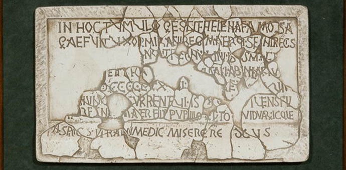
Queen Helena’s Inscription
The Croatian queen Helena (Jelena) is known to us only by the information obtained from her famous epitaph, the inscription on her sarcophagus, found in 1898, at Gospin otok in Solin. She is a person often described in the Croatian national historiography as a benefactor, in the romantic manner of the 19th and the beginning of the 20th century ecclesiastical and civil practices. However, her importance was quite different, and the role she had, according to her epitaph, was quite similar to roles of other rulers of the time. The inscription states, among other information, the tasks she was to perform as the queen, mirroring duties of her contemporary rulers in accordance with the firstly, Roman and then Byzantine (Justinian’s) law. This is evidence of connections of the then Croatian state and its dynasty with the spiritual system of the contemporary world: both the West-European – the Carolingian, and the Eastern – the Greek-Byzantine.
The inscription will be paid some more attention here.
The queen’s crushed sarcophagus was restored and most of it’s inscription read with the benefit of the enormous patience and diligence of the archaeologist Frane Bulić. Scientists who studied the sarcophagus’ fragments added some missing details to it’s reading, but the essence has remained unchanged. Here is our interpretation of the famous inscription: In this grave lies the famous Helena, the wife of King Mihajlo and the mother of King Stjepan. She ruled the kingdom. The eighth day before the ides of October she was buried here in peace in the 976th year from the incarnation of the Lord, in the fourth indiction, the fifth lunar cycle, the seventh epact, the fifth sun cycle which corresponds to the sixth. She, who in life was queen, also became the mother of orphans and the protector of widows. You who look, say: “God have mercy on her soul!”
Why is this inscription so important? Firstly, because it reveals the family relationship between two Croatian kings, through their deceased wife and mother respectively. Secondly, because it states the exact date of the queen’s death, which is a rare case in old Croatian history. Furthermore, it shows a continuation of the Salonitan tradition of epitaphs which, again, testifies on the spiritual and cultural level of the then Croatian society. And finally, also of great importance, the inscription has preserved a brief formula that reveals the presence of Roman and Byzantine legal norms on the Croatian state. The inscription, namely, says that Queen Helena was the mother of orphans and the protector of widows.
This role of a protector and a tutor, namely, was not a personal virtue; it was being given to rulers and bishops. Thus, for instance, the epitaph of the Split archbishop Martin, a Helena’s contemporary, reads that he protected widows and was the father of orphans. There is a similar text in the letter sent by the Croatian King Zvonimir, immediately after his coronation, to Pope Gregory VII to express his loyalty. In his letter, the king promised to protect the poor, widows and orphans. Namely, this Croatian prince was crowned a king by the Pope’s emissary, Gebison, in 1075, in the Salonitan Basilica of Ss. Peter and Moses, today known as Hollow church. These epitaphs are fine evidence of Croatia having been at the level of European countries at that time. Namely, these and similar formulas are known of in the then civilised countries, in Carl the Great’s codes, for instance.
Times of Croatian Dignitaries and Dalmatian Municipalities
In the late Middle Ages, when the local political situation significantly changed by the creation of the political coalition with the Arpad dynasty. When the economic development that followed the social evolution resulted in the formation of a specific form of Dalmatian feudalism, instead of one town – Salona, here collide the interests of two towns – Trogir and Split, and of the masters of the Klis fortress . These are the Croatian Middle Ages that in the example of the area of Solin-Salona, show their manifold and always interesting physiognomies.
When, in the constant course of social events, the economic prerequisites were created for a multi-class state in these parts, there also occurred a change of the dynasty in Croatia. The dignitaries needed a king who would be a formal authority and would not prevent them from establishing their own independence. The domestic dignitaries kept a significant amount of independence under the Hungarian Arpads and the French Angevins. The independence being proportional to their own power, richness and distance from the king. Therefore, a dynasty with its throne as far as in Hungary was quite favourable for them. This is, among other peculiarities, the essence of the new era that commenced in the 12th and continued into subsequent centuries. For this reason, some clans in Croatia, the Šubići Bribirski for instance, became powerful dynasts of a European level. The language of their communication was of little importance to the people of that time, especially to dignitaries, their ethnicity of even lesser. The only important factor was the social status, which made them inclined to accept foreigners as their seniors, often far from where events took place. The dignitaries gradually became “foreigners” to each other, bitter enemies constantly fighting for domination over an area, road, bridge, harbour, field, etc. That was one of the features of medieval society.
The Area of Solin till Turkish Attacks
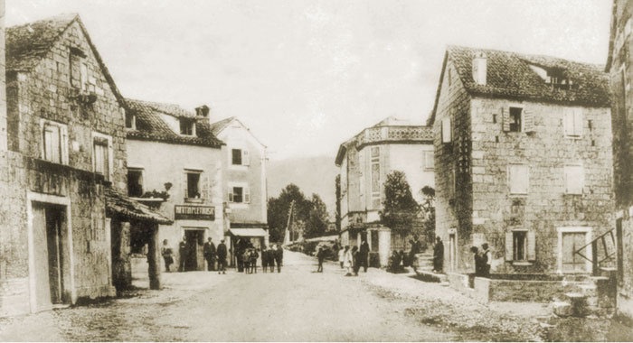
At the location of the ancient Salona no town, or even an organised settlement was ever built. Instead, smaller settlements appeared – villages: Prosik, Kuk (Kučine), Smoljevac, the present Vranjic, Sućurac below Sv. Jure of Putalj, and a larger number of hamlets of lost names. These facts are drawn mostly from toponyms recorded in historic documents, also from preserved churches, excavated graveyards, various ruins, archaeological researches, incidental finds (Glavičine, Gajine, Majdan) or some toponyms still is use.
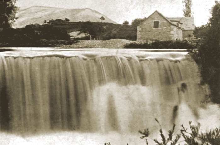
During the late Middle-Age centuries, the importance of the Salo, today known as Jadro, was large since it was the border between the lands of Split and those of Klis, later between the Turkish and the Venetian holdings. As a matter of fact, it was a formal border, rather than real. In the 16th and the 17th centuries, namely, the Turks often invaded the Split lands, but there were opposite examples, as well. There is no doubt that this area was of extreme importance for both of them: for the Turks to prevent Klis from getting assistance, to inhabitants of Klis for obtaining such assistance in the easiest possible way. These conflicts elevated the importance of the nearby Solin harbour (<). Besides being a fictitious border between the Western, Venetian, and the Eastern, Ottoman, worlds, the river was also important economically with numerous mills powered by its water since early Middle Ages.
In the 13th century, at the time when trading relations between the coast and the hinterland started improving, control over the Klis mountain pass, i.e. the fortress, and the benefits obtained from the traffic travelling through the pass, caused struggles between many highly esteemed Croatian families. Among the first and the most highly esteemed were the Šubići. Even before the Klis episode of the history of Bela IV, when the Hungarian king, in 1242, took refuge in Dalmatia – in Klis, Split and Trogir…. Fleeing before the Tatars, the Šubići dispossessed Prince Domagoj of his fortress and subjected it to their rule. The Šubići were especially present here at the beginning and during the first half of the 14th century. At the time, they were peers to the higher European feudalists, guests at the courts of the Anguins in Naples and the Pope in Rome; they negotiated with Venice, and ruled a vast area along the coast and deep into the continent. Klis was undoubtedly the real seat of feudal power of a mighty and esteemed family. The already mentioned interests of two towns; Trogir and Split, and of the Klis rulers, interlace in the Solin area, and several centuries passed before the first foreboding about the Turkish hazards at the end of the 15th and the beginning of the 16th century.
On the other hand, confrontations of municipal authorities, princes and town masters with the Venetians and with Croatian dignitaries, who at the time of the Croato-Hungarian kings (13th-15th century) had numerous interests in all the four places: Klis, Solin, Split and Trogir, provide no important information for the story of Solin that we are telling here.
In order to depict these relations by one example, we are to mention Domaldo, the prince of Split and a mighty feudalist, who ruled Klis in the beginning of the 13th century. He distanced himself from his subjects in Split, to make enemies with them while having his seat in Klis. Such historic personalities were numerous.
The Second Fall of Solin – the Turkish Conquest
At the end of the 15th century the Turkish menace became obvious in these parts as well, since this expansive force came quite close to Dalmatia. Having conquered the Bosnian state in 1463, it could attack and loot Dalmatian lands with ease: Turkish companies advanced closer and closer to Solin. Thus, just like at the times of the Ghotic wars, at the time of Justinian, in the 6th century, Klis once again shared the destiny of similar hinterland fortifications: of Bribir and Knin, also partly of Skradin, that defended lands to their west. It was an important point of defence and, therefore, an important target to the conqueror.
As it was in such a situation, the area of Solin became important for both the Venetians and the Turks. Valuable information is reported by the Turkish travel-writer, Evliya Çelebi (1611-about 1682): “In order to conquer Klis, Gazi-Husref Bey proposed (to the headquarters in Istanbul) in 1534 that Solin should be fortified. His proposal was accepted and he erected fortifications around the town, built in dressed stone and of square ground-plan.” Undoubtedly, that is Gradina. It is still hard to say whether this is refortification of the fortress considered by F. Bulić and Lj. Karaman to have been built by the Split bishop Ugolino de Mala Branca in the 14th century. The people of Klis conquered and demolished it, the Turks took it back, rebuilt and reinforced it, since it was important for the functioning of Solin harbour.
A Turkish company reached the Split Field and looted it as early as in 1471. The Venetians, who controlled Dalmatia, however, avoided conflicts with Istanbul for political reasons. They were concerned about the overall political situation, including trading and economic relations, especially in the eastern Mediterranean. Yet bloody and cruel wars lasted for one and a half centuries: there were numerous clashes between the Turks, the Islam converts, the Morlachi, outlaws, companies made up of the people of Poljica, Split, Kaštela and European mercenaries – with changing fortunes of war, but with dreadful casualties and looting that impoverished the entire area. The climax of this tragic past was the persistent strife of the already mentioned captain Petar Kružić, who died in Solin harbour in 1537, lacking support by both his own king and Europe. All his begging and visits to the Hungarian dignitaries and to the Pope in Rome were in vain: the entire area of Klis fell to the Turks. The new masters, lead by Rustem-Pasha, founded Novo selo (New Village) for the survivors in 1541. The local population farmed lands, as serfs, for both Split landowners and the Turks. This was a sign of the newly created coexistence of the conquerors and the natives.
The Venetian Era
What the ancient town of Salona looked like in the 16th century can be read from a report by the Venetian writer and clerk G. B. Giustiniani: “Nobility, vastness and greatness of Salona can be felt from the still visible volts and arches of the splendid theatre (amphitheatre! Ž.R.), from large blocks of finest marble scattered over the fields, from the beautiful column made of three marble pieces still standing upright where an arsenal is said to have been by the sea, as well as from many arches of remarkable quality standing on high marble columns, as high as a hand may throw, that supported aqueduct that took water from Salona to Split… All around there are many ruins and remains of palaces, and many marble fragments with ancient inscriptions. The soil, however, has risen and covered old stones and the most valuable remains.” This well illustrates the gradual decline of the town, the filling up of the large area, alluviums created by rains, creeks and Solin’s river that significantly changed its bed and contributed in the re-configuration of the entire delta, from Šuplja crkva and Gospin otok to the sea.
Just like the people of Klis and their masters in previous centuries, the Turks damaged buildings and obstructed the development of the Solin and Split areas in the 16th and the 17th centuries. Just as the archbishop Ugolino da Mala Branca built the fortification of Prosik (we have learned of it from documents, however, there are no traces of it at the Prosik locality) in the 14th century to defend himself from the people of Klis, so the Venetian authorities built a fortification at the bridge of Solin to defend Split from the Turks in the beginning of the 16th century.
Yet, during the Turkish occupation of a significant part of Dalmatia, there were also prosperous decades, peaceful relations and fruitful coexistence between the Turks, the local population and the people of Split. One such story on romance between the young Turk, Adel, and the local Croat girl, Mara, has been turned into romantic literature and two operas, poem Adel and Mara by the Croatian 19th century poet Luka Botić, set into music by two composers, Josip Hatze and Ivo Parać.
However, of much more importance were the fruitful trading relations that contributed to the prosperity of Split, where, by the sea coast, they built lazarettos, warehouses for transiting merchandise and for quarantine of goods and travellers. In the late 16th century, namely, in the circumstances of quite peaceful Venetian-Turkish political, military and economic relations, Split became an important centre for the transiting trading with the Muslim continent. Consented by the Venetian Republic, and advocated by the well-known Spanish Jew, Daniel Rodrigo, building of the lazarettos was commenced next to Diocletian palace’s southeast tower in 1581. The Split lazarettos were among the largest in the Mediterranean for some time: a large complex of buildings with storehouses, customs house and bank, followed also by quarantine houses for people and goods that arrived in Split by sea or through Solin, Trilj or Klis, or that were to travel through Sinj deep into the continent. Split harbour had well-built wharves for the large number of vessels docking. Fruitful trading relations contributed to the development of both Split and the entire area.
This advantageous trading by sea and land was stopped by wars between Venice and Turkey, and the town of Split and its entire geographical and spiritual surroundings returned to a more modest volume, as for many centuries to come this prosperous trading factor, connecting the coastlands and the continent, disappeared. It will be re-established as late as the beginning of the 20th century when railway lines were built from Split, firstly to Sinj and still much later to Zagreb (1925).
Solin Area and Klis Fortress under the Turkish Rule
The conquered Klis became the seat of the administrative region known as Klis and Lika Sandjak, extending from Konjic, Bosansko Grahovo and Gračac almost to the coast, to Skradin and Benkovac. This large and heterogeneous land was divided into smaller civil and military administrative units. In such a military-administrative system, Klis, a frontier crossing place next to Venetian lands by the coast, was of particular importance and was protected by a strong garrison. For strategic reasons, the Venetian governors in Dalmatia often tried taking it over from the Turks: in 1571 and again next year, then in 1578 and 1586. Finally, in 1596, the Split nobleman Ivan Alberty gained access to Klis, but for a short period only. Besides military reasons, that were of a changing nature, the course of events was also influenced by the pragmatic relations prevailing between Venice and Turkey, and/or between these two on one side and the Hapsburgs on the other.
The global political conditions in the Mediterranean resulted in two Venetian-Turkish wars: the War of Candia (1645-1649) and the War of Morea (1684-1699). In the former, the area of Solin with Klis behind it the site of large battles since the Republic was to take this important strategic point in order to control the hinterlands to Sinj and on to Knin and Livno. In 1648, a mighty Venetian army, made up of large numbers of mercenaries and local the Croat population, placed under the command of the general Leonardo Foscolo and some other well respected commanders of the time, attacked Klis from Solin Field and took it after a battle that lasted only a few days. Until the Turkish defeat near Sinj in 1715, there were numerous skirmishes, collisions and much looting, but after that event, its memory being celebrated in Sinj every year by the Alka equestrian tournament, the frontier was pushed back far enough to bring peace to this entire area.
Solin Area After the Departure of the Turks: Venetian, French and Austrian Administrations
The area of Solin at the end of the Venetian-Turkish wars was deserted and wasted: Solin was liberated in 1647 and Klis in 1648. After that, at the end of the 17th century, general Leonardo Foscolo colonised over six hundred families to the unattended and deserted area of Solin and Vranjic, mostly on the Vranjic Peninsula, to Kaštela, Solin, Klis and Kamen, as it is believed. Most of them were from the nearby Dalmatian hinterland, mostly from Drniš, bringing with them their scarce cattle: a few herds of sheep, a few oxen and some horses. These people were of various religions, including Muslims and Orthodox Christians who, having arrived here, accepted Catholicism while looking for jobs with Split and Kaštela landlords. The immigrants also brought their customs with them, their words and nicknames, although some of the old, Turkish ones, remained in use, as well. Their ethnic and linguistic characteristics, times and events are still recognisable in many names, surnames and toponyms (Meterize, Arapovac, Megdan, Markezina Greda, etc.).
Many settlers were to serve in the army, their task being to defend the area they inhabited. Especially because of, from 1715 till the battle of Sinj, much looting and clashes with Turkish units that occasionally raided from the hinterland to Klis and Split Field.
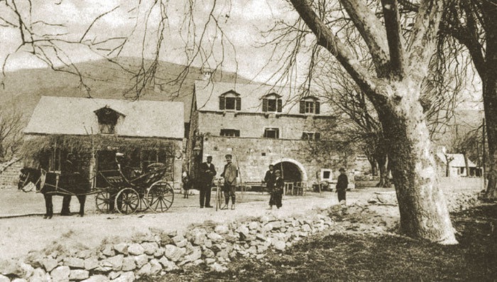
In the 18th century, regeneration started of the scarce local farming and cattle rearing, caused by both natural and economic improvements. According to the Split Archbishopric records, the population of Solin and Vranjic in about 1725 was some six hundred which was a relatively high number. In Solin, however, no significant development occurred and it remained one of the smaller settlements that appeared or was regenerated throughout Dalmatia at the time. It gained some economic importance from the newly built mills on its river that provided their services to a large coastal and hinterland areas. New churches were being built or in the modest Dalmatian rural Baroque style and decoration, which featured creating an intimate atmosphere. A 1658 source reports that in Kamen, a village formed after the Turks had left this area, a new church was built, dedicated to St. Michael (sv. Mihovil). There were similar examples in other hamlets and settlements. In Klis a church was dedicated to the Assumption, and in Vranjic to St. Martin (sv. Martin). The church of Our Lady On-the-Island (Gospa na Otoku) (>) in Solin was annexed.
The Solin ruins attracted attention since as early as the Renaissance: the humanists of Split, writer Marko Marulić and the nobleman Smino Papalić strolled here copying and collecting Roman inscriptions. Yet, there were much less noble intentions, too. In 1678, for instance, the Venetian governor P. Valier rewarded the poet Jeronim Kavanjin for his services to the Republic in stone blocks from Solin’s structures. The poet was helped about his private construction ambitions in this way. In 1711, the Split archbishop S. Cupillio was also allowed to use the stone of Solin. At the end of the 18th century, the governor of Zadar was sent many crates of stone and sculptures.
There are many examples, and from among those less drastic it should be mentioned that the people of Split, Vranjic and Solin incorporated Roman sculptures, inscriptions, architectural fragments and other old stones in building their houses. In his book Topografia e scavi di Salona, published in Trieste in 1859, F. Carrara also wrote: “The history reveals reasons for creation of such ruins and, as I said in the beginning, rather than by the barbarity of the grandfathers, they are caused by vandalism of the grandchildren. Salona has always been taken by the local population as a query. In the 15th century, its stones enabled to a large extent erection of the bell tower of Split and the cathedral of Trogir, from here the Venetians kept taking stone for their palaces and the people of Split for their walls, the people of Solin were constantly taking it for anything they built…” It should be mentioned here, however, that the troubles encountered by the ruins of Solin were no exemption in contemporary Europe. Such plundering by Venetian governors, military officers and local officers were not practised only in Salona and, as deemed sometimes, not only in detriment to Solin’s monuments. In many uneducated minds a deserted town, all built in stone, is still deemed to be ruined and stones from such a “ruin” to be collected or plundered. This is a practice experienced throughout Europe. This is a common occurrence. Specifically, a well documented military strategy was the that ordered destruction of the amphitheatre of Salona.
The beginning of the 19th century was a time of growth in the overall cultural and spiritual atmosphere where archaeological artefacts gradually gained importance and value: they were being gathered in collections and museums (the Archaeological Museum of Split was founded in 1820), books were being written on them (F. Lanza, F. Carrara), they were being documented by pens and brushes of both local and foreign travel writers and painters.